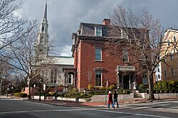
Back College Hill Historic District (parke sa Tinipong Bansa, Rhode Island) CEB Distrito Histórico de College Hill (Providence) Spanish
College Hill Historic District | |
 Benefit Street | |
 Interactive map showing the location for | |
| Location | Roughly bounded by the Providence and Seekonk Rivers, Olney, Hope, and Governor Sts., Carrington and Whittier, Providence, Rhode Island |
|---|---|
| Coordinates | 41°49′35″N 71°24′12″W / 41.82639°N 71.40333°W |
| Architect | Multiple |
| Architectural style | Mid 19th Century Revival, Federal |
| NRHP reference No. | 70000019 |
| Significant dates | |
| Added to NRHP | November 10, 1970[1] |
| Designated NHLD | December 30, 1970[2] |
The College Hill Historic District is located in the College Hill neighborhood of Providence, Rhode Island. It was designated a National Historic Landmark District on December 30, 1970. The College Hill local historic district, established in 1960 (and expanded in 1990), partially overlaps the national landmark district. Properties within the local historic district are regulated by the city's historic district zoning ordinance, and cannot be altered without approval from the Providence Historic District Commission.[3]
- ^ "National Register Information System". National Register of Historic Places. National Park Service. March 13, 2009.
- ^ "College Hill Historic District". National Historic Landmark summary listing. National Park Service. Archived from the original on June 6, 2011. Retrieved June 28, 2008.
- ^ Providence Planning Department
© MMXXIII Rich X Search. We shall prevail. All rights reserved. Rich X Search

